Nottingham tram map
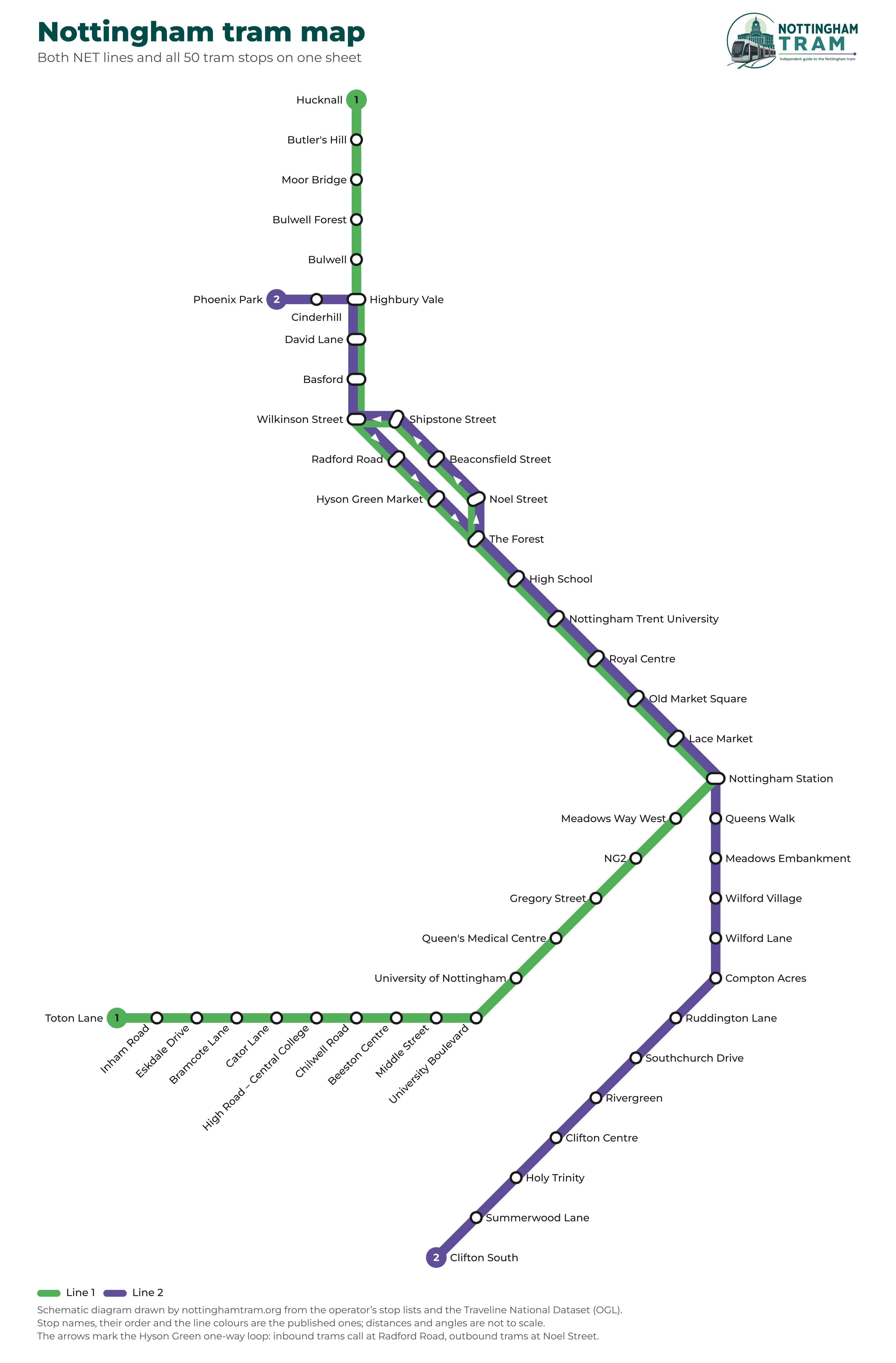
Both lines and all 50 stops on one sheet — a schematic diagram drawn from the published data. Free to download as a PDF.
 Drag to move · scroll or pinch to zoom · double-click to zoom in
Drawn by us from the published data. Own work (CC BY 4.0) — open the full-size image or download the PDF below.
The map as a PDF
Nottingham tram map · PDF
Vector PDF, about 398 KB: it stays sharp however far you zoom in, and prints at any size. Keep it on your phone for when there is no signal.
How this map is made
It is not the operator’s map touched up: it is drawn from the data. All 50 stops, the order of each line and the colour of each line come from the operator’s own published lists and the Traveline National Dataset, cross-checked against OpenStreetMap.
It is a schematic diagram, in the tradition Harry Beck started with the Tube map in 1933: every stretch of track runs at 0°, 45° or 90°, and the stops are spaced evenly instead of geographically. That is a trade and it is worth saying out loud — distances are not to scale. What you get back is a sheet you can actually read: Hucknall and Clifton South are fifteen miles apart and half the network is squeezed into the city centre, so a true-to-scale map of Nottingham ends up with a knot of unreadable labels in the middle. North is still at the top, and no leg points more than 45° away from the direction it really runs in.
One thing on this map that most maps of Nottingham leave out: the Hyson Green loop is drawn as two tracks, with arrows, because that is what it is. Towards town the trams run past Radford Road and Hyson Green Market; away from town they take Noel Street, Beaconsfield Street and Shipstone Street, on different streets. A single line through there would have to leave three stops out — and would tell you that you can catch a tram back the way you came, which you cannot.
The map is ours and you may use and share it with attribution (CC BY 4.0). The operator’s own route map is its work and is not reproduced here.
Line 1, stop by stop
Hucknall – Toton Lane
36 tram stops; 16 of them (Highbury Vale to Nottingham Station) are also served by Line 2, on the same platform — no change needed, take whichever tram comes first
Line 2, stop by stop
Phoenix Park – Clifton South
30 tram stops; 16 of them (Highbury Vale to Nottingham Station) are also served by Line 1, on the same platform — no change needed, take whichever tram comes first
Where the two lines run together
The 16 stops both lines share
Between Highbury Vale and Nottingham Station both lines run over the same track and call at the same platform. There is no interchange to make: take whichever tram arrives first, and between them they run roughly twice as often as either line on its own.
Frequently asked questions
Tram times on this page come from the Traveline National Dataset (TransXChange, Open Government Licence); stop names, lines and fares are those published by Nottingham Express Transit (NET). Nottingham Tram is an independent guide: it is not run by Nottingham Express Transit (NET) and has no connection with the operator. Check thetram.net before you travel.